Severe Weather

Severe weather encompasses: thunderstorms, lightning, hail, microbursts (wet and dry), tornadoes, and windstorms. Severe weather is most commonly associated with the term thunderstorm. Thunderstorms develop when warm, moist, air rises and condenses as it cools at higher altitudes. As the moisture condenses it causes the surrounding air to continue to warm, intensifying the instability in the air mass. We’ve likely all experienced a severe weather event at some point in our lives; and probably followed it up with the thought, “Where did that come from?”
The following paragraphs present brief descriptions of what some of these hazards are and how they develop.
- Lightning develops as liquid and ice particles collide and discharge electrons, causing the buildup of large electrical fields. Once those fields become large enough, the field ‘sparks’ creating a lightning strike. The insulation properties of air allow the fields to become exceptionally large before discharge. (Did you know that in areas where the soils are very dry, and have a high salt content, the electricity from a lightning strike can skitter across the ground surface because it has nowhere to go?)
- Windstorms form from both thunderstorms and occur near a storm/low pressure edge. Strong winds form in advance of low pressure systems, or as severe pressure gradients develop as high mountain air cools in close proximity to warmer valley air such as occurs with the Washoe Zephyrs along the eastern flank of the Sierra Nevada Mountains. FEMA considers wind speeds severe when velocities exceed 58 miles per hour.
- Tornadoes are high energy, rotating, columns of air which typically occur at the trailing edge of a very strong thunderstorm. The most violent tornadoes can produce wind speeds exceeding 250 miles per hour. Tornadoes can occur in any state, but because they are spawned by a cold air mass overriding a layer of warm air, they occur more frequently east of the Rocky Mountains.Hail is formed due to cyclical freezing and partial thawing as particles alternately fall and get carried back up in strong updrafts in an unstable air mass. FEMA considers a thunderstorm severe when hail exceeds ¾ inch.
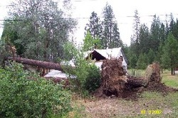
- Microbursts can produce wind damage (dry or wet) and localized flooding (wet) as intense rainfall concentrates in available channels such as streets, streams, and rivers. (It was a microburst that wreaked such havoc in Quincy in July, 2002.)
- Thunderstorms present a potential for both direct and indirect hazardous impacts. Direct impacts include high winds, large hail stones, and rain. Indirect impacts include flash flooding and wildfires. Based on NOAA (National Oceanic and Atmospheric Administration) records, hail greater than ¾” and up to 15” has been experienced in and around Portola.

